
Grand Theft Auto VI is set in Leonida, Rockstar's fictional sunshine state. Rockstar currently organises its world material into six named destinations: Vice City, Leonida Keys, Grassrivers, Port Gellhorn, Ambrosia and Mount Kalaga National Park.
The screenshot atlas below uses only images that Rockstar itself files under those six names. That distinction matters: a scene can be observed without guessing its road, district or exact position on a fan-made map.
Rockstar has not released the full in-game map, a scale bar, official dimensions, a road list or confirmed boundaries. This page therefore documents the places that are published without pretending the complete geography is known.
There is one honest way past that limit: triangulation. The interactive map on this page plots several hundred places whose positions the GTA mapping community computed from official footage alone. Every pin states the frames it was derived from, and leak-derived survey data is excluded.
- Setting
- The state of Leonida (fictional Florida)
- Confirmed regions
- Six
- Primary city
- Vice City
- Official location screenshots
- 42 across the six region groups
- Full official map
- Not published
- Official map dimensions
- Not published
- Era
- Modern day
- Previous Vice City appearance
- GTA: Vice City (2002), set in 1986
The interactive map of Leonida
Community analysisRockstar has not published a map. What it has published is footage, and footage can be surveyed. The map below plots 374 places whose positions the GTA mapping community triangulated from 112 official frames: trailers, region screenshots and the postcards on Rockstar's own site. The survey data comes from the public-domain gtamaplib project.
How to read this map
Every pin is an estimate from camera triangulation, not an official coordinate. Where the surveyors published a residual error, the pin states it. Place names are the community's working names, and many borrow the real Miami building they resemble. Leak-derived material never reaches the pins: 72 survey points that leaned on the leaked world-editor image were excluded under our leak policy.
Two backgrounds are available. The community map is YANIS, the Mapping Community's hand-drawn map of Leonida, placed under the pins with gtamaplib's published calibration; it is community cartography whose own legend marks which parts are speculative, and it is not an official map. The survey view is drawn from our leak-filtered data alone: the glow is survey density and the faint lines are bridges and streets joined from their own survey fixes. Rockstar has not published a map or boundaries.
The landmark research layer adds 1402 places from map.gtadb.org, the gtamaplib project's landmark database, each pairing an in-game position with the real Florida building it appears to depict. The same rule applies to it: 523 entries batch-tagged as leak-derived were excluded at import, and entries with unconfirmed names say so on their card.
Hover a pin for its name, source frames and residual error. Zoom with the buttons or pinch; the mouse wheel zooms after you click the map once.
Community pins
Registered members can suggest places for this map. A suggestion must state its basis, meaning which official trailer, screenshot or postcard shows the place, and a moderator reviews it before it appears. Approved pins render in white on the map with the member credited.
Log in to suggest a place for this map. Suggestions state their basis and are reviewed by a moderator before they appear. You can also discuss the map with other members below.
Every triangulated place, by region
The same 374 places as plain text. Counts are places, not survey points: the source dataset holds 1245 raw survey fixes, collapsed here to one entry per named place.
Vice City 129 places Vice City Region guide
- 100 Biscayne Blvd
- 1000 Venetian Way
- 1111 Lincoln Rd
- 123 NE 36th St
- 12th St Lifeguard Tower
- 1500 Ocean Dr
- 1500 Ocean Dr (S)
- 50 Biscayne Blvd
- Akoya Condominium
- Art Deco Welcome Center
- Asia Brickell Key
- Ball near Grassrivers Sign
- Bank of America Financial Center
- Beach
- Biscayne Island
- Blue Diamond
- Brown Hotel Sign
- CC (3)
- CC (9)
- Canal (Hotel Valetta)
- Capri South Beach
- Carbonell Brickell
- Citigroup Center
- Construction Crane (Vice Beach)
- Container Crane
- Continuum on South Beach
- Cruise Ship
- Cruise Terminal D
- Cruise Terminal G
- Di Lido Island
- East Venetian Causeway Bridge
- FAA Miami ATCT
- Fisher Island
- Flagler Memorial Island
- Flagler on the River
- Flamingo South Beach
- Golf Course
- Grass (MIA)
- Green Diamond
- Helipad 1
- Helipad 2
- Helipad Path
- Highway Sign (404)
- Hotel Breakwater
- Hotel Victor
- Icon at South Beach
- InterContinental Miami
- Jade Ocean Condos
- Jenny Hostel
- KC01
- KC02
- KC03
- KC04
- KC06
- KC07
- KC08
- KC09
- KC10
- KC11
- Kaseya Center
- Lake
- Lake near VCIA
- Latitude on the River (S)
- Loews Miami Beach
- Loft Downtown II
- MIA North Terminal Tower
- MacArthur Causeway
- Marina Blue
- Marker (MIA)
- Marriott Miami Biscayne Bay
- Miami Beach Parking Garage
- Miami Tower
- Miami-Dade County Courthouse
- Murano Grande
- New World Center
- Nine at Mary Brickell Village
- North Vice City Bridge
- North Vice City Coast
- North-South Highway
- Old City Hall
- One Miami Condominium East
- One Miami Condominium West
- Opera Tower
- Palazzo del Sol
- Park
- Pelican Harbor Marina
- Pelican Harbor Radio Tower
- Picnic Island A
- Picnic Island B
- Picnic Island C
- Picnic Island D
- Pier (Flamingo)
- Pole near Signature Hangar 2
- Port
- Portofino Tower
- Reworld Miami-Dade
- Rivo Alto Island
- Road (MIA)
- Round Water Tower
- Royal Palm South Beach
- Royal Palm South Beach (N)
- Sherry Frontenac Oceanfront Hotel
- Signature Hangar 2
- Skyviews Miami Observation Wheel
- Southeast Financial Center
- St. Moritz Hotel
- Stack
- Star Island Bridge
- Star Island Water Tower
- Stephen P. Clark Government Center
- Sunset Harbour South Condo
- Ten Museum Park
- The Floridian
- The Gates Hotel South Beach
- The Grand
- The Ritz-Carlton Bal Harbour
- The Tides South Beach
- The Waverly South Beach
- Three Tequesta Point
- Trésor Tower
- Unknown Object
- Unknown Sphere
- Venetian Isle Condominium
- Vice City Sign
- Vice River
- Vizcayne North Condominium
- Vizcayne South Condominium
- W South Beach
- Wells Fargo Center
Leonida Keys 83 places Leonida Keys Region guide
- 102180 Overseas Hwy
- 104000 Overseas Hwy
- 105 Front St
- 118 Poinsetta Dr
- 180 Pompano Dr
- 200 Pompano Dr
- 500 Pompano Dr
- 99353 Overseas Hwy
- Anchor Island
- Blimp
- Blimp Bay
- Blimp Inlet
- Blimp Key
- Blimp Road
- Blue Billboard (Key Lento)
- Bridge Island
- Broken Keys Bridge
- East Key
- Grassrivers River Mouth
- House C
- House D
- House with Pier
- Island A
- Island B
- Island C
- Island D
- Island E
- Island G
- Island H
- Island I
- Island J
- Island K
- Island N
- Island S
- Island U
- Island V
- Island W
- Island X
- Island Y
- Island Z
- Jason's House (Basketball Hoop)
- Jason's House (Boat Ramp)
- Jason's House (Front Stairs)
- Jason's House (Garden Table)
- Jason's House (Main)
- Jason's House (North Veranda)
- Jason's House (Pillar 1)
- Jason's House (Pillar 10)
- Jason's House (Pillar 11)
- Jason's House (Pillar 5)
- Jason's House (Pillar 6)
- Jason's House (Pillar 8)
- Jason's House (Pillar 9)
- Jason's House (Power Pole)
- Jason's House (Rear Stairs)
- Jason's House (Roof)
- Jason's House (South Veranda)
- Jason's House (Upper Veranda)
- Jason's House (Window 3)
- Jason's House (Window 4)
- Jason's House (Window 5)
- Key Lento
- Lake Surprise Viaduct
- Marina Club at Blackwater Sound
- Naval Air Station Key West (Control Tower)
- Naval Air Station Key West (Radar Tower)
- New Bahia Honda Bridge
- Old Bahia Honda Bridge
- Old Bahia Honda Bridge (Barrier)
- Old Seven Mile Bridge
- Rocks (Grassrivers)
- SFUWO School
- Seven Mile Bridge
- Small Radio Tower (Key Lento)
- Sombrero Key Light
- Squalo Billboard
- Tree on Island K
- Trees B (Grassrivers)
- Trees C (Grassrivers)
- Trees D (Grassrivers)
- Trees E (Grassrivers)
- Unnamed Building #1 (Blimp Key)
- Vake Island
Grassrivers 33 places Grassrivers Region guide
- 1450 Brickell Ave
- Box in Backyard
- Brickell Arch
- Catalan Key Coastline
- Central District Wastewater Treatment Plant (Tank)
- Dirt Road (Grassrivers)
- Double Pole
- Floodgate
- Four Seasons Hotel Miami
- Hamlet Coastline
- Homestead Water Tower
- Infinity at Brickell
- Keys Bridge
- Lamp Post
- Large Grassrivers Bridge
- Magic City Casino (?)
- Office in the Grove
- One Broadway
- Park Grove Condominium
- Prison Tower
- Red Billboard (Hamlet)
- Rickenbacker Causeway Bridge
- Small Grassrivers Bridge
- Small Keys Bridge
- Stiltsville
- Tall Billboard
- Turkey Point Nuclear Power Station
- Two Tequesta Point
- Virginia Key
- Virginia Key Coastline
- WDNA FM
- Watson Bay
- White Billboard (Hamlet)
Port Gellhorn 22 places Port Gellhorn Region guide
- Bay
- Billboard (Hank's Waffles)
- East-West Highway
- Easy Hill
- Juice Fruit Sign
- New Foundation Church
- North Port Gellhorn Coast
- Oval Yellow Sign
- PGH Barrier Island
- PGH Canal
- PGH Island A
- PGH Island B
- PTCC (1)
- PTCC (2)
- PTCC (3)
- Port of Tampa Container Crane
- Pylon
- Radio Tower #1 (Port Gellhorn)
- Ship
- Train Signal (S)
- Uncle Jack's Valley
- Water Tower (West Port Gellhorn)
Ambrosia 69 places Ambrosia Region guide
- 1500 Sonora Ave (Silo)
- 1500 Sonora Ave (Tank)
- 1800 Club
- 22 Biscayne Bay
- 3001 Gordon Hwy (Water Tower)
- 3400 Transmitter Rd
- 419 NE 4th Ave
- Ambrosia Airfield
- BB Hill
- Big Cat Cage Roof
- Billboard (South Ambrosia)
- Building A (Ambrosia)
- Building B (Ambrosia)
- Building near Pool
- Canal A (Ambrosia)
- Canal B (Ambrosia)
- Canal C (Ambrosia)
- City View Parking Garage
- Conveyor near Pile
- Dark Billboard (Ambrosia)
- Elephant
- Factory A (Ambrosia)
- Factory D (Ambrosia)
- Gas Station (Leonard County)
- Industrial Building 1 (Ambrosia)
- Industrial Building 2 (Ambrosia)
- Lamppost near Starlet Motel
- Liquor Store
- Margaret Pace Park
- Marina (Stockyard)
- New Wave Condominiums
- Orlando Station
- Path A (Ambrosia)
- Path B (Ambrosia)
- Path C (Ambrosia)
- Path D (Ambrosia)
- Path E (Ambrosia)
- Path F (Ambrosia)
- Quantum on the Bay Condominium (N)
- Quantum on the Bay Condominium (S)
- Radio Tower (Ambrosia)
- Road (South Ambrosia)
- Road A (Ambrosia)
- Road B (Ambrosia)
- Road C (Ambrosia)
- Road D (Ambrosia)
- Road E (Ambrosia)
- Road F (Ambrosia)
- Route 35
- Sailboat Cay
- Sidewalk Creep
- Starlet Motel
- Starlet Motel Parassol 1
- Starlet Motel Parassol 2
- Starlet Motel Pool
- The Crimson
- Train Signal (Ambrosia)
- Train Tracks (Ambrosia)
- Trees near Wheelabrator
- US Sugar Mill (Factory)
- USSM Smokestack
- Uptown Lofts
- Warehouse 4 (Ambrosia)
- West Venetian Causeway Bridge
- Wheelabrator South Broward
- White Silos (E)
- White Silos (W)
- Wyman (Initial)
- Wyman (Pool)
Mount Kalaga National Park 36 places Mount Kalaga National Park Region guide
- 252 N Tyndall Pkwy
- 536 Richard Jackson Blvd
- Ambrosia Bridge
- Ambrosia Main St
- Ambrosia Road
- Beige Billboard
- Billboard with Diversity Motif
- Billboard with Irregular Shape
- Billboard with Oval Motif #1
- Black Bison
- Domed Hills Sign
- Escher Bridge
- Guard Booth (Ambrosia)
- Highway Bridge
- Hill Road
- Island LLA
- Island LLB
- Lake Leonida
- Lakeside Canal
- Large Billboard (Ambrosia)
- Mount Waffles
- Quarry
- Red Boxville
- Springfield Community Church
- Sunshine Skyway Bridge
- Tall Double Billboard
- Traffic Sign
- Train Tunnel
- Waffles Arrow
- Waffles Billboard
- Waffles Ridge
- Waffles Sign
- Water Tower (North Port Gellhorn)
- White Pole
- Worker A (Ambrosia)
- Worker B (Ambrosia)
Wider Leonida 2 places
Triangulated positions that fall outside the six published region groups.
- East Coast
- Light Pollution
The six published regions at a glance
Details stated by Rockstar or directly visible in its region-labelled screenshots.
| Region | Rockstar-published details | What remains unknown |
|---|---|---|
| Vice City | Ocean Beach, Little Cuba, Tisha-Wocka flea market and VC Port are named | District boundaries and street plan |
| Leonida Keys | Tropical archipelago; beaches, bars and dangerous waters | Island names and exact extent |
| Grassrivers | Wetland waterways with mangroves, airboats and alligators | Settlement names and boundaries |
| Port Gellhorn | Former vacation destination with cheap motels and closed attractions | Scale and street plan |
| Ambrosia | Allied Crystal sugar refinery and a local biker gang are named | Town names and boundaries |
| Mount Kalaga National Park | Northern-border park with hunting, fishing and off-road trails | Exact extent and access points |
The official Leonida screenshot atlas
One official image for each named region. Open a card for the full guide to that place and every screenshot Rockstar has published of it.
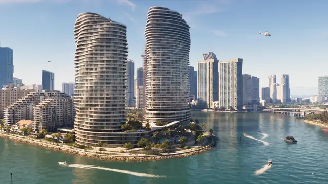
Rockstar names Ocean Beach, Little Cuba, Tisha-Wocka flea market and VC Port among the city's areas and destinations.
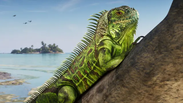
A tropical archipelago with bars, beaches and waters Rockstar characterises as both beautiful and dangerous.
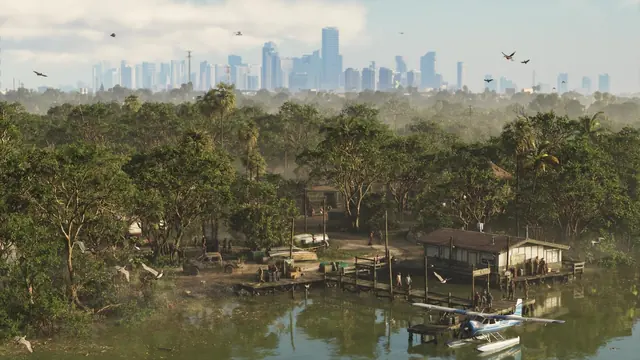
Leonida's wetland region: waterways, mangroves, airboats and alligators are visible in official material.
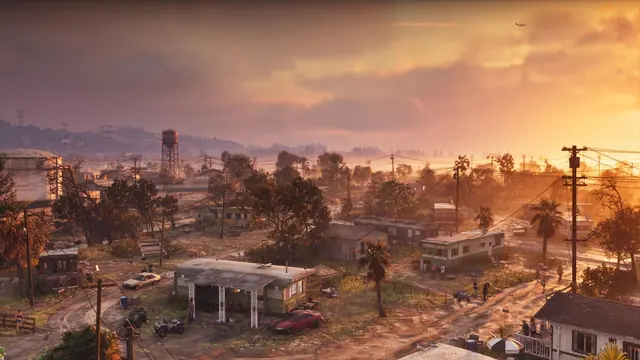
A former vacation destination now defined in Rockstar's copy by cheap motels, closed attractions and empty strip malls.
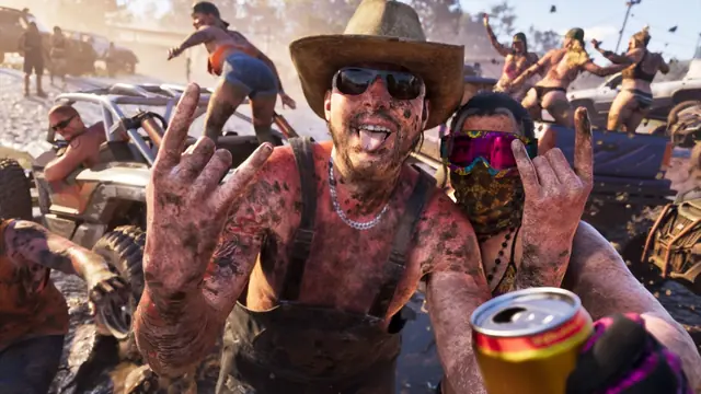
An inland industrial area where the Allied Crystal sugar refinery provides jobs and a local biker gang supplies much else.
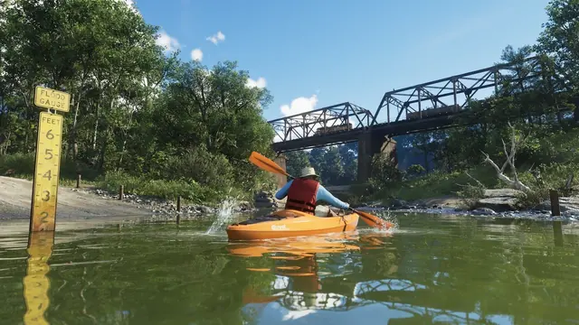
A national park on Leonida's northern border with hunting, fishing and off-road trails, surrounded by remote backwoods.
Vice City is the centre, not the whole
Rockstar calls GTA VI a return to modern-day Vice City, and the marketing leans hard on that phrase. It is the most valuable piece of nostalgia the company owns.
Read the framing carefully
Vice City is the heart of the map. By Rockstar's own description it is the most detailed city the studio has built. Our Vice City guide covers it in full.
It is not the edge of the world. Five other regions sit around it.
Why the trailers look Vice City heavy
Most footage so far is Vice City footage, because Vice City is the sell.
The other regions have had far less screen time. That is a marketing choice, not a statement about how much of the game happens there. Leonida Keys, Grassrivers and Mount Kalaga each have their own guide.
The map in numbers
Only the first two rows are official. The rest is what people wish were official.
| Figure | Number | Status |
|---|---|---|
| Named regions | 6 | Confirmed by Rockstar |
| Location screenshots published | 42 | Counted from the official library |
| Cities | 1 named | Vice City; others unnamed |
| Square miles | Unknown | Every figure circulating is an estimate |
| Official full map | 0 | None published |
How big is it, really?
Nobody outside Rockstar can answer that from published material.
Where the numbers you have seen come from
The precise figures circulating online come from community reconstruction projects. They are not an official map or a specification.
Those projects can be good analysis. They are not interchangeable with Rockstar's six named regions, and we keep them out of the fact box. Our map size page handles the estimates and labels them as estimates.
What is not confirmed about the map
- Whether any region from a previous GTA game is accessible.
- The total number of enterable interiors.
- Whether the map expands post-launch, as GTA Online's did.
- Any road-level detail outside what official footage has shown.
- The exact scale figure - Every number in circulation is an estimate.
Everything in The GTA 6 Map
7 in-depth articles, each reviewed and dated. Confidence labels tell you how firm each one is.
Mount Kalaga National Park
Hunting, fishing and off-road trails on Leonida's northern border, with remote communities beyond the...

How Big Is the GTA 6 Map?
Every number you have read is an estimate. Here is where the estimate comes from, how confident you should be...
Ambrosia, Region Guide
Allied Crystal keeps the region working while a local biker gang supplies almost everything else. The confirmed...
Port Gellhorn, Region Guide
Cheap motels, closed attractions and rust. Port Gellhorn is the anti-Vice City, and it is doing something no...
Grassrivers, Region Guide
Wetland, wildlife and almost no infrastructure. Grassrivers is the least populated region on the map and...
Leonida Keys, Region Guide
A causeway chain over turquoise water, described by Rockstar as 'the gateway to paradise' - And, in the same...
Vice City, Region Guide
Rockstar calls it the most detailed city it has ever built. Here is what forty years of in-fiction time did to...
Frequently asked questions
Is there an official GTA 6 map?
No. Rockstar has not published a map of Leonida. Every detailed map circulating is a community reconstruction built from trailer footage, and we label them as estimates.
How many regions are in the GTA 6 map?
Six are confirmed by Rockstar: Vice City, Leonida Keys, Grassrivers, Port Gellhorn, Ambrosia and Mount Kalaga National Park.
Is the GTA 6 map bigger than GTA 5?
Rockstar has not published comparable map dimensions. Community reconstructions suggest a larger world, but that is analysis rather than an official measurement.
Is Vice City the whole map?
No. Vice City is the largest urban area and the marketing centrepiece, but it is one of six regions in the state of Leonida.
What real place is Leonida based on?
Florida. Vice City corresponds to Miami, the Leonida Keys to the Florida Keys, Grassrivers to the Everglades, and Port Gellhorn to the Gulf-side Panhandle resort towns.
Can you swim and dive across the whole map?
Scuba diving is a confirmed activity and the Keys are built around water traversal, so open water is clearly navigable. The precise boundaries of the swimmable area have not been detailed.
0 comments
No comments yet. Sign in with Google to start it. Reading needs no account.